Ham Use
to Expand
Due to frequent flooding to a depth of several feet the Ham is unsuitable for any purpose other than seasonal grazing and hay. Nonetheless some amazing schemes have been suggested and approved for the “Development" of this area, now classed as a Site of Special Scientific Interest. (See “Recreation"). None have borne fruit, except in the most vulnerable part, that northwards pointing wedge of land from Knaves' acre to the Goutts. Roads and waterways slice this patch into neat sections. Reading from the tip southwards, the Goutts, the Hammockst the Hangings, at one time called the Pale Pill.
The Goutts are no more. Submerged totally beneath the waters of a Marina and the railway embankment it no longer has any identity. It was part of the Hannocks (sic) (granted to Edward Haslewood and Edward Tomlinson in 1581. At that time it supported two mills, the remains of one being visible in the early 1700s. The rest of the "Hammocks" remained as a single unit until 1983.
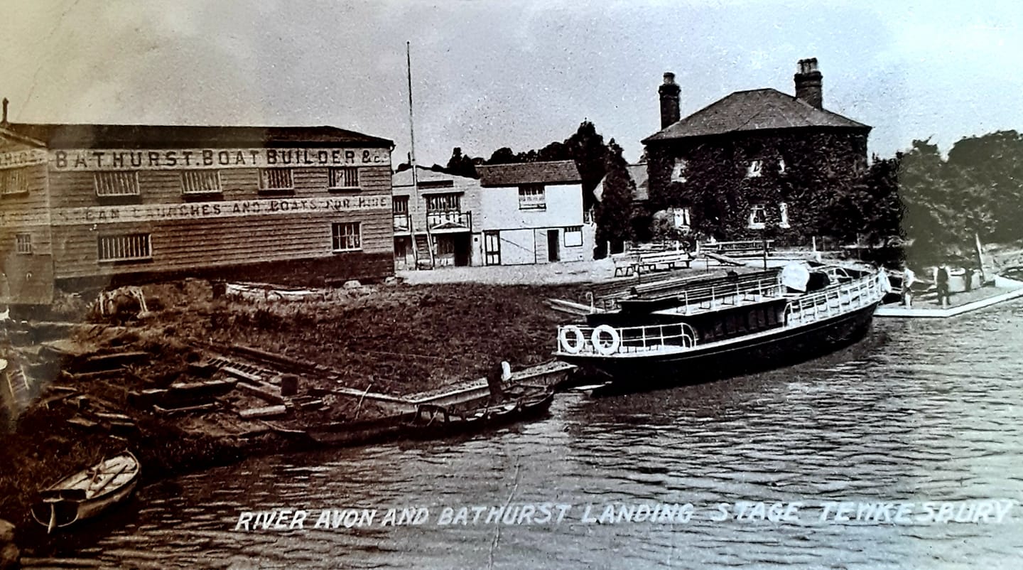
There was a great upsurge in boat-building during the Second World War. An investment of £5,000 on a slipway and corrupted iron shed paid good dividends in RAF launches. The rusting shell of this enterprise was a bone of contention between council and company for twenty years after the war ended. By 1966 the boat firm in this island was reduced to hiring out broken-down old cabin cruisers as holiday accommodation and tottering on the brink of bankruptcy. The owner drew up a grandiose scheme for development of the entire site. In retrospect its scope when matched to the site and the town is patently a dream project. In the 1960s when the property boom was making fortunes for some anything was possible. Four years later the plans were still paper castles and in May, 1970, the "First Mortgagee", who remained anonymous, foreclosed and the Hammocks went up for sale.
From 1970 to 1978 "The plan" staggered from amendment to amendment and from developer to developer, with little to show for it on the ground. The house was demolished. Piling was put in along the Stanchard Pit bank but so little work, as distinct from drawing had been done that the nature of the subsoil was unknown and the steel sank into the depths to such an extent that extra lengths had to be welded on to keep them above water level. This lack of knowledge attended the construction of the first building which was supported partly on piles and partly on a mound of earth. Subsidence made known its effects almost immediately and has bedevilled it since first built in 1983.
It was about this time that the Lower Hammocks were sold off separately to Southern Leisure Cruises. Both Upper and Lower Hammocks are now, so far, mainly used for the town's growth industry, parking for cars.
Upper Hammocks included Stanchard Pit, 1a. 0r. 12p. of water with the Iand acreage two perches less. Lower Hammocks was 2a. 1r. 4p. in extent. The whole didn't amount to 5 acres. One optimistic developer, with the Receiver on the horizon, felt his offer of the lot for £1,000,000 was reasonable. On that basis the Ham has a "Development" value of £35,000,000, which is probably the reason so many keep pecking away at it.
The lock is now the property of the Lower Avon Navigation Trust.
Between this lock & the Quay Bridge Highway lies the Hangings, once known as the "Pale Pill". From at least 163? this was part of the Essex Estate. By indenture dated 4/5th. December, 1827 this piece of ground, described as "useless" was sold to John Moore, vintner. It had two sitting tenants, George Hammerton, a barge-owner, and William and Michael Procter, these two last-named were said to be occupying, the dock, boat-yard and storehouse known as the "Soaphouse". Their tenure was a 21-year lease from 1818. Moore built up part of the site, a necessary act as the new weir on the Severn permanently raised the level of the water in Old Avon by several feet.
Seen from the east this site looked like a wide, shallow "U", the inner sides of which sloped down to the river like a muddy beach, ideal for landing and drawing up smell craft. This "beach" was bisected by a rill of water from the sluice between the rivers, in the centre of the base of the "U". A map of 1836 shows a barren patch with one small building in the south-east corner, the "Soaphouse".
By 1861 this area was classed as "waste" and controlled by the Local Board of Health, except for the "Soaphouse" which had now become the "Engine house", with a small yard. It was part of the steam mills offered for sale in 1861 by John Moore. This appears to have been bought by Rice &, Co. judging from the following: précis of a minute of the Local Board of Health meeting held on 7th December, 1863. Entitled "Improvements at the Quay", it goes on to record a request by a representative of Healings Ltd. It was proposed to erect a steam mill on the site of the warehouse lately in the occupation of Messrs Rice, just over the bridge and leading: to the locks, which property was lately owned by the Earl of Essex, bought by the late John Moore and included a quantity of uncovered land, with a small slip in front of the warehouse.
Healings believed they owned this land but, as a matter of courtesy and form, not a matter of right, they requested the permission of the Board and its approval. It was granted. The paperwork was completed on 4th April 1864 and included the following paragraph; "For this work (Building of a mill) they find it necessary to enclose a further part of the waste land and also to carry buildings in a northerly direction beyond the line of the present watermark. This land has for a long time been open to the public." There are two points of interest here. One is the mention of the slip in front of the warehouse which later occasioned some public comment; the other is the reference to "Waste". Waste was owned by the Local Board of Health. The warehouse, "lately occupied by Messrs. Rice" can only have been the block to the left of the road across the bridge.
This figures in a later application by Healings Ltd. It would therefore seem that Healings Ltd. founded their mill in 1864. Unfortunately it is a matter for the record that in April 1862 an employee suffered a fatal accident in a flour bin at Healing's flour mill. Without further research it is not possible to be sure but it may be that there was some interchange of property between Rice and Healing and the two mill sites.
The licence grant for the construction of a new mill included this clause "For this work they find it necessary to enclose a further part of the waste land and also to carry building in a northwardly direction beyond the line of present watermark. This land for a long time open to the public." The firm express readiness now to dedicate to the public all such parts of land to west of storehouse and yard as not required. The mill was constructed on a base of 80 x 60 sq. ft. leaving a triangular piece of land so dedicated, until 3rd July 1864 when 130 sq. yds. was asked for, and given. In 1872 the reminder was also occupied (see Letter to Press, 1872). All three licences above were leases for a period of 60 years.
From the foregoing it is clear that the part of the "Pale Pill" known as the "Hangings" between the lock and the sluice remained "Waste". It was used until at least 1962 for the drying of fishing nets. Nor was the narrow strip of land along the New Avon from Key Bridge to the sluice sold or leased. No further development took place here.
Comments